Crime and Safety in Portstewart
Last updated: 07 Jun 2026
Portstewart is the safest small town in Londonderry, and is among the top 10 most dangerous overall out of Londonderry's 21 towns, villages, and cities. The overall crime rate in Portstewart in 2026 is 30 crimes per 1,000 people. This compares favourably to Londonderry's overall crime rate, coming in 25% lower than the Londonderry rate of 40 per 1,000 daytime population. For England, Wales, and Northern Ireland as a whole, Portstewart is the 418th most dangerous small town, and the 2,642nd most dangerous location out of all towns, cities, and villages.
In February 2026, Portstewart had the worst crime rate in Londonderry for violence and sexual offences, with 21 crimes reported and a crime rate of 2.5 per 1,000 daytime population. January 2025 was also a bad month for Portstewart residents, when it was Londonderry's most dangerous area for burglary, recording 1 crime at a rate of 0.12 per 1,000 daytime population.
The most common crimes in Portstewart are violence and sexual offences, with 108 offences during 2026, giving a crime rate of 13. This is 9% higher than 2025's figure of 99 offences and a difference of 1.07 from 2025's crime rate of 12. Portstewart's least common crime is robbery, with 0 offences recorded in 2026.
Portstewart 2026 Crime Scorecard
Safest
Small Towns, Londonderry
17% lower, regional crime rate
Northern Ireland
59% lower, national crime rate
England, Wales & NI
Local Crime in Context
As of April 2026, the crime rate in Portstewart is 17% lower than Northern Ireland and 59% lower than the England, Wales & Northern Ireland overall figure.
Portstewart Crime Rate Over Time
| Portstewart | |
| Northern Ireland | |
| England, Wales & NI |
Portstewart Crime Map
Incidents mapped in Portstewart represent the time frame between January 2016 and April 2026. Each point on the map represents an area where crimes have been recorded locally.
Use Crime Map
Hover over a point to see a breakdown of crime types recorded at that location. You can also filter by individual crime types, or use a combinations of offences to visualise the data you need.

See How Portstewart Compares
You can compare Portstewart's crime statistics against any other town, village, or city from across the country. Search for a location's name below to see how they stack up.

Introduction to Portstewart's crime statistics
This crime profile provides a detailed view of crime and safety around Portstewart up to April 2026, the most recent data release available. The crime figures and statistics have been calculated across each of Portstewart's 317 postcodes using three area sizes for comparison:
- Within a Five-Minute Walk
- Within a Ten-Minute Walk
- Within a Fifteen-Minute Walk
Individual crime risk scores and index figures are for the 12-month period ending April 2026 unless otherwise stated.
CrimeRate Insights
Looking into a specific address in Portstewart? CrimeRate Insights reports convert raw numbers into practical insight for any location, from single addresses and postcodes, up to major towns and cities.
Crime rates don’t happen by themselves; they follow people and patterns. Where crowds gather - near pubs and late-night venues, around the station, by supermarkets and forecourts - incidents naturally concentrate.
That doesn’t mean an area is "bad"; it usually means footfall is higher.
Your report explores these factors in a calm, non-judgemental way, putting the numbers in context and helping you spot what’s typical for places like this.
Crime Risk Scores
Portstewart • 12 Months Ending April 2026
The typical five-minute walk within Portstewart has a crime risk score of 266. This is based on analysis of 317 nearby areas within Portstewart, with "most" referring to roughly two thirds of the nearby locations.
Crime risk scores are on a scale of 1 to 1,000 and consider the severity of the crimes involved, as determined by sentencing guidelines. A score of 1 represents the lowest risk, and 1,000 the highest risk. This approach ensures that - unlike overall crime rate figures - bicycle theft is not given the same importance in Portstewart's risk scores as, for example, robbery, or violence & sexual offences.
Within a five-minute walk of the typical location in Portstewart, crime risk scores are typically around 266, while in Londonderry they are average 345.
Areas within a ten-minute walk typically see crime risk scores of 341 (315 for Londonderry), and scores within a fifteen-minute walk are most often around 367 (Londonderry 281).
Trends in Crime Risk
Portstewart
Calculated via Seasonal and Trend decomposition using Loess, the Seasonality Adjusted line represents the original data with seasonality subtracted, and the Trend line has been plotted unadjusted. Overall trend direction has been identified using the Mann-Kendall trend test, and rate calculated from the slope of the best-fit line identified from linear regression.
The 10-year trend indicates a decrease of 30% in Portstewart's crime risk score. This is potentially a strong signal of how the crime risk is evolving. Cross-referencing with major cultural events and Covid's impact during this time is advised.
Looking at the previous five years, the trend in Portstewart's crime risk score is down by 21%. While potentially a good indicator of the overall risk trend, analysis may offer further insight when combined with the checks mentioned above.
Over the last year, Portstewart's crime risk score has shown an upward trend of approximately 12%, indicating that the risk profile is going up. This is an extremely short time period for crime trend analysis, and caution should be exercised when interpreting this figure.
Crime Rates and Indexes
Portstewart
The CrimeRate Index shows how crime rates compare against the national average.
1.0 equals the average
2.0 is double
3.0 triple
0.5 is half and
0.25 a quarter.
Highest Crime Rates
Portstewart • 12 Months Ending April 2026
Excluding other crime and other theft because their geographic location is often not relevant, anti-social behaviour as its definition is too wide, and bicycle theft for its specificity.
Possession of Weapons offences have a crime rate of 0.36 reports per 1,000 people in Portstewart, which is 2.40 times the national average. This figure is calculated from 3 crime reports logged by Police Service of Northern Ireland during the 12-month period ending April 2026.
For the same period, Police Service of Northern Ireland recorded 46 reports of Criminal Damage and Arson in Portstewart, resulting in a crime rate of 5.43 reports per 1,000, and a CrimeRate Index of 0.86.
The crime rate for Theft From the Person is 0.86 times the national average at 0.12 reports per 1,000. This is from 1 crime report reported to Police Service of Northern Ireland.
Most Significant 3-Year Increases in Crime Types
Portstewart
Excluding other crime and other theft, anti-social behaviour, and bicycle theft, and calculated with the same STL method described in Trends in Crime Risk, using CrimeRate Index figures to identify crime types that are trending above or below the national average, and the analysis timeframe limited to the last three years.
Shoplifting offences are trending upwards, though the CrimeRate Index three years ago is too low to measure, and the trend should be reviewed with caution.
Burglary offences are trending upwards, and have a CrimeRate Index of 0.50 for the month of April 2026.
Three years ago, the monthly Burglary CrimeRate Index was 0.40 times the national average, and the current trend indicates an increase of 25% over this timeframe.
Most Significant 3-Year Decreases in Crime Types
Portstewart
Calculated with the same methodology as the largest increases section above.
Criminal Damage and Arson offences are trending downwards, and have a CrimeRate Index of 1.09 for the month of April 2026.
Three years ago, the monthly Criminal Damage and Arson CrimeRate Index was 2.06 times the national average, and the current trend indicates a decrease of 47% over this timeframe.
Violence and Sexual Offences are trending downwards, and have a CrimeRate Index of 0.39 for the month of April 2026.
Three years ago, the monthly Violence and Sexual Offences CrimeRate Index was 0.73 times the national average, and the current trend indicates a decrease of 47% over this timeframe.
Drugs offences are trending downwards, and have a CrimeRate Index of - for the month of April 2026.
Three years ago, the monthly Drugs CrimeRate Index was 1.14 times the national average, and the current trend indicates a near-complete decrease over this timeframe.
Crime Type Breakdown & Heat Map
Portstewart • 12 Months Ending April 2026
Size and colour reflect the CrimeRate Index figures for each type of crime.
Portstewart | Londonderry | Northern Ireland | |||||||
|---|---|---|---|---|---|---|---|---|---|
| Crime Type | Count | Rate | Index | Count | Rate | Index | Count | Rate | Index |
| Anti-Social Behaviour | 185 | 21.86 | 1.55 | 5,528 | 17.92 | 1.27 | 43,885 | 17.62 | 1.25 |
| Bicycle Theft | 1 | 0.12 | 2.00 | 30 | 0.10 | 0.15 | 428 | 0.15 | 0.21 |
| Burglary | 14 | 1.68 | 0.72 | 282 | 0.91 | 0.29 | 2,573 | 1.02 | 0.33 |
| Criminal Damage and Arson | 46 | 5.43 | 0.86 | 1,865 | 6.05 | 0.96 | 12,926 | 5.19 | 0.83 |
| Drugs | 11 | 1.31 | 0.72 | 803 | 2.59 | 0.84 | 7,582 | 3.03 | 0.98 |
| Other Crime | 7 | 0.84 | 1.12 | 453 | 1.47 | 0.79 | 3,080 | 1.23 | 0.66 |
| Other Theft | 28 | 3.31 | 0.69 | 1,003 | 3.27 | 0.57 | 7,842 | 3.15 | 0.55 |
| Possession of Weapons | 3 | 0.36 | 2.40 | 138 | 0.45 | 0.53 | 1,231 | 0.52 | 0.61 |
| Public Order | 4 | 0.48 | 0.30 | 143 | 0.48 | 0.08 | 869 | 0.36 | 0.06 |
| Robbery | - | - | - | 34 | 0.12 | 0.11 | 468 | 0.19 | 0.16 |
| Shoplifting | 20 | 2.37 | 0.44 | 975 | 3.18 | 0.45 | 8,273 | 3.32 | 0.47 |
| Theft From the Person | 1 | 0.12 | 0.86 | 45 | 0.15 | 0.10 | 295 | 0.12 | 0.08 |
| Vehicle Crime | 8 | 0.95 | 0.52 | 228 | 0.73 | 0.17 | 2,067 | 0.83 | 0.19 |
| Violence and Sexual Offences | 108 | 12.76 | 0.42 | 6,212 | 20.11 | 0.66 | 41,940 | 16.83 | 0.55 |
Download | |||||||||
Total Crime by Year
Portstewart | Londonderry | Northern Ireland | |||||||
|---|---|---|---|---|---|---|---|---|---|
| Year | Count | Rate | Index | Count | Rate | Index | Count | Rate | Index |
| 2026 | 251 | 29.73 | 0.53 | 12,211 | 39.61 | 0.55 | 89,574 | 35.94 | 0.50 |
| 2025 | 305 | 36.06 | 0.66 | 12,771 | 41.39 | 0.56 | 93,985 | 37.72 | 0.51 |
| 2024 | 358 | 42.33 | 0.74 | 14,151 | 45.87 | 0.61 | 100,335 | 40.25 | 0.53 |
| 2023 | 416 | 48.69 | 0.85 | 15,072 | 48.62 | 0.62 | 107,639 | 42.99 | 0.54 |
| 2022 | 364 | 41.19 | 0.76 | 14,412 | 45.81 | 0.60 | 103,005 | 40.88 | 0.53 |
| 2021 | 499 | 55.08 | 1.02 | 13,305 | 41.87 | 0.61 | 91,280 | 36.14 | 0.53 |
| 2020 | 351 | 38.46 | 0.68 | 12,900 | 40.54 | 0.55 | 97,350 | 38.54 | 0.52 |
| 2019 | 348 | 37.76 | 0.66 | 11,903 | 37.36 | 0.49 | 96,251 | 38.09 | 0.50 |
| 2018 | 354 | 37.98 | 0.72 | 11,769 | 36.88 | 0.52 | 93,560 | 37.05 | 0.52 |
| 2017 | 360 | 38.15 | 0.81 | 11,829 | 36.93 | 0.58 | 95,010 | 37.52 | 0.59 |
| 2016 | 114 | 12.08 | 0.80 | 4,146 | 12.91 | 0.68 | 31,832 | 12.57 | 0.66 |
Download | |||||||||
Portstewart Compared to Nearby Small Towns
12 Months Ending Apr 2026
| Small Town | Total Crimes | Crime Rate | Rate Difference |
|---|---|---|---|
| Limavady | 823 | 62.29 | 110% more dangerous |
| Magherafelt | 544 | 45.00 | 51% more dangerous |
| Coleraine | 1,481 | 47.64 | 60% more dangerous |
| Portstewart | 251 | 29.73 | - |
Comparing Portstewart to the UK's Major Cities
12 Months Ending Apr 2026
| City Name | Crime Rate | Rate Difference |
|---|---|---|
| Portstewart | 29.73 | - |
| Cardiff | 79.55 | 168% more dangerous |
| Newcastle upon Tyne | 82.69 | 178% more dangerous |
| Sheffield | 84.09 | 183% more dangerous |
| Leicester | 97.87 | 229% more dangerous |
| Bristol | 104.64 | 252% more dangerous |
| Birmingham | 105.05 | 253% more dangerous |
| Liverpool | 106.48 | 258% more dangerous |
| Leeds | 107.10 | 260% more dangerous |
| Nottingham | 107.74 | 262% more dangerous |
| Westminster | 125.00 | 320% more dangerous |
CrimeRate Pro
To download charts and tables, you must subscribed to CrimeRate Pro
You can find out more, or get a CrimeRate Insights report that includes further analysis.
Recent Crimes in Portstewart
The 20 most recent crime reports in Portstewart.
| Date | Crime Type | Location | Outcome |
|---|---|---|---|
| April 2026 | Anti-social behaviour | On or near Swilly Road | |
| April 2026 | Anti-social behaviour | On or near Atlantic Bay | |
| April 2026 | Anti-social behaviour | On or near Lever Park | |
| April 2026 | Anti-social behaviour | On or near Mill Road | |
| April 2026 | Anti-social behaviour | On or near Seafield Park South | |
| April 2026 | Anti-social behaviour | On or near Coleraine Road | |
| April 2026 | Anti-social behaviour | On or near Seafield Park South | |
| April 2026 | Anti-social behaviour | On or near Seaview Drive North | |
| April 2026 | Anti-social behaviour | On or near Coleraine Road | |
| April 2026 | Anti-social behaviour | On or near Mill Road | |
| April 2026 | Anti-social behaviour | On or near Atlantic Bay | |
| April 2026 | Burglary | On or near Harbour Road | |
| April 2026 | Other theft | On or near Coleraine Road | |
| April 2026 | Other theft | On or near | |
| April 2026 | Shoplifting | On or near Dunsuivnish Drive | |
| April 2026 | Shoplifting | On or near Dunsuivnish Drive | |
| April 2026 | Violence and sexual offences | On or near Cromore Station | |
| April 2026 | Violence and sexual offences | On or near Cromlech Court | |
| April 2026 | Violence and sexual offences | On or near Cromore Station | |
| April 2026 | Violence and sexual offences | On or near Loguestown Road |
Methodology & Data Sources
Portstewart Crime Report
Data Sources & Processing
Every month, CrimeRate processes crime reports from data.police.uk, the UK's official provider of open crime report data. Each crime report includes anonymised coordinates, most often "snapped" to the middle of the nearest street, or to the nearest major landmark. The reports also include the month and year the crime was reported, as well as the type of crime.
Data releases on data.police.uk happen once a month, with a two-month delay. This means that, for example, crimes reported in Portstewart during October 2026 will typically become available in December 2026. The latest release is for Apr 2026 and was released in Jun 2026. To provide current and historical crime statistics, CrimeRate processed 61,669,232 crime reports for the latest release.
Portstewart Data Points
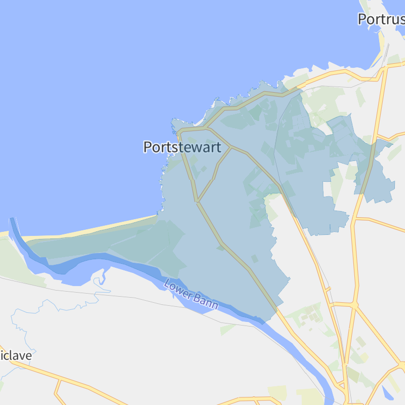
For Portstewart, CrimeRate uses the geographic boundaries provided by The Northern Ireland Statistics and Research Agency in the 2015 release of their Settlements dataset, using the SA2015CD column value N11000184.
Due to the 2021 Census being conducted during a UK-wide Coronavirus lockdown, the daytime population figures released so far cannot be relied on for purposes such as comparing crime rates. Instead, CrimeRate uses Portstewart's daytime - or "workday" - population of 6,185 from NISRA's 2011 Census for calculations throughout the site.
All geographic boundaries use the full resolution - extent of the realm versions where provided to avoid missing crime reports near coastlines and rivers - the banks of the Thames in particular - that would otherwise not be included when using the clipped to the coastline datasets.
Calculating Crime Rates
CrimeRate locates the UK region, county, and town/city/village locality for each crime report, and calculates the crime rate by taking the sum of all crime reports, dividing it by the locality's daytime / "workday" population, and multiplying the result by 1,000 to get the crime rate per 1,000.
Crime Risk Score Calculations
CrimeRate calculates crime counts for local, nearby, and wider areas for every postcode in England, Wales, and Northern Ireland. The postcodes locations are deduplicated by a process that ensures distinct points are approximately 50 metres apart. This process removes the bias that would otherwise come from counting the same crimes several times in heavily populated areas.
Using a custom algorithm developed in-house, CrimeRate applies a crime severity weighting to each area's crime counts, based on the type of crime reported. This increases or decreases the crime count, or zeroes it out entirely, depending on the crime type. A separate crime severity rate is then calculated, standardised, and scaled to fit the crime risk score range of 1 to 1,000, with 1 being the lowest score, and 1,000 the highest.
Crime risk scores undergo further analysis per town, city, and village plus other areas including police forces and neighbourhoods. CrimeRate uses percentiles to work out the most common range of crime risk scores in each locality. This includes identifying the high and low bounds where approximately 68% of scores fall, and finding the median (50th percentile) for easy reference.
The crime types with a weight of zero are: Anti-Social Behaviour; Bicycle Theft; Other Crime; Other Theft; and Shoplifting. The highest weights to are assigned to Violence & Sexual Offences, and the lowest to Vehicle Crime.
Frequently Asked Questions
Crime in Portstewart